


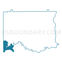
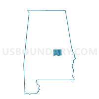
Millbrook Civic Center, Elmore County, Alabama
About
Outline

Summary
| Unique Area Identifier | 521711 |
| Name | Millbrook Civic Center |
| County | Elmore County |
| State | Alabama |
| Area (square miles) | 22.45 |
| Land Area (square miles) | 19.95 |
| Water Area (square miles) | 2.50 |
| % of Land Area | 88.85 |
| % of Water Area | 11.15 |
| Latitude of the Internal Point | 32.45934830 |
| Longtitude of the Internal Point | -86.35475810 |
Maps

Graphs
Select a template below for downloading or customizing gragh for Millbrook Civic Center, Elmore County, Alabama


Neighbors
Neighoring Voting District (by Name) Neighboring Voting District on the Map
- 2D Montgomery Boys Club Voting District, Montgomery County, AL
- 2J Hunter Station Community Center Voting District, Montgomery County, AL
- 4H North Montgomery Community Center Voting District, Montgomery County, AL
- 4I Union Academy Baptist Church Voting District, Montgomery County, AL
- Church of the Living Water, Autauga County, AL
- Coosada City Hall, Elmore County, AL
- Coosada City Hall-A, Elmore County, AL
- Millbrook Civic Center, Elmore County, AL
- Millbrook Civic Center, Elmore County, AL
- Prattmont Baptist Church, Autauga County, AL
- Trinity Methodist Church, Autauga County, AL
- Upper Kingston Community Center, Autauga County, AL
- Victory Baptist School, Elmore County, AL
- Victory Baptist School, Elmore County, AL
Top 10 Neighboring County Subdivision (by Population) Neighboring County Subdivision on the Map
- Montgomery CCD, Montgomery County, AL (189,183)
- Prattville CCD, Autauga County, AL (42,682)
- Elmore CCD, Elmore County, AL (26,447)
Top 10 Neighboring Place (by Population) Neighboring Place on the Map
- Montgomery city, AL (205,764)
- Prattville city, AL (33,960)
- Millbrook city, AL (14,640)
- Coosada town, AL (1,224)
Top 10 Neighboring Unified School District (by Population) Neighboring Unified School District on the Map
- Montgomery County School District, AL (226,849)
- Elmore County School District, AL (72,158)
- Autauga County School District, AL (54,571)
Top 10 Neighboring State Legislative District Lower Chamber (by Population) Neighboring State Legislative District Lower Chamber on the Map
- State House District 75, AL (60,140)
- State House District 88, AL (56,499)
- State House District 77, AL (34,998)
- State House District 78, AL (30,880)
Top 10 Neighboring State Legislative District Upper Chamber (by Population) Neighboring State Legislative District Upper Chamber on the Map
- State Senate District 25, AL (157,932)
- State Senate District 30, AL (139,399)
- State Senate District 26, AL (120,666)
Top 10 Neighboring 111th Congressional District (by Population) Neighboring 111th Congressional District on the Map
Top 10 Neighboring Census Tract (by Population) Neighboring Census Tract on the Map
- Census Tract 205, Autauga County, AL (10,766)
- Census Tract 208.02, Autauga County, AL (10,435)
- Census Tract 310, Elmore County, AL (6,516)
- Census Tract 311, Elmore County, AL (4,221)
- Census Tract 313, Elmore County, AL (3,968)
- Census Tract 51.01, Montgomery County, AL (3,689)
- Census Tract 60, Montgomery County, AL (3,611)
- Census Tract 207, Autauga County, AL (2,891)
- Census Tract 312, Elmore County, AL (1,809)
- Census Tract 3, Montgomery County, AL (1,666)
Top 10 Neighboring 5-Digit ZIP Code Tabulation Area (by Population) Neighboring 5-Digit ZIP Code Tabulation Area on the Map
- 36067, AL (26,954)
- 36108, AL (21,306)
- 36066, AL (19,089)
- 36054, AL (15,066)
- 36022, AL (13,092)
- 36110, AL (12,997)
- 36104, AL (9,468)
- 36020, AL (1,123)